Sunday, April 14, 2013

Feedback on the Khatib Bongsu Park Connector

Over the weekend, a few of my friends were discussing about Singapore's National Cycling Plan via email. One of our friends offered to collate our ideas and suggestions to relay to the right government agency folks.

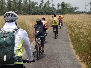
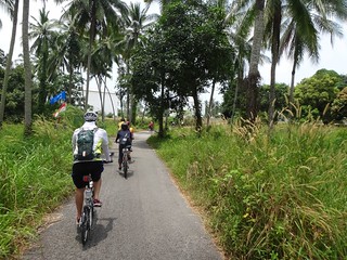
I love our Park Connectors. I ride on the Khatib Bongsu park connector most often (sometimes connecting all the way to Woodlands Waterfront, through the Admiralty connector). I've noticed minor improvements to the Khatib Bongsu connector in the last two years. There's still room for a better/ safer experience for cyclists and pedestrians.

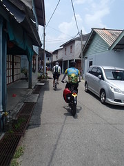
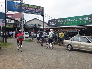
There was a suggestion that I should blog about my suggestions. It's fresh off my mind anyway, since my wife and I just completed an early evening 16km ride today, to the end of Simpang Kiri.

Ideally I should include actual images of the parts I've described. But I didn't really plan to give a comprehensive list until after the ride. Hope the map screenshots, with the descriptions, would help.

Well, I'd love to show the URA or NParks people first hand. Like a Ride & Review session. Wouldn't mind taking my vacation time on a weekday to meet them (wouldn't want them to work on a weekend). Ride along the path, point out actual situations. Also I'd like to be educated on why things were designed in certain ways or perhaps the constraints they faced.

Feedback on the Khatib Bongsu Park Connector

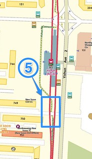
1) From the junction at Yishun Ave 1 & Yishun Ave 2, there's a stretch of asphalt that seemed worn out. The painted speed stripes seemed particularly high. It appeared as if the asphalt on parts unpainted were badly eroded (I've seen newer paved bike paths and they are definitely smoother). Going over the stripes slowly, as designed, was extremely jarring. I suspect most cyclists will choose to ride on the smoother pedestrian path. Which defeated the purpose of having the cycling path.
Khatib Bongsu PCN - 1


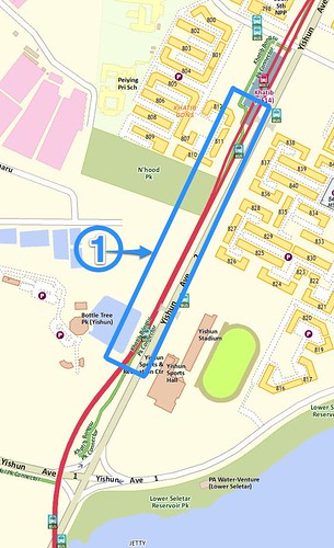
2) Along Yishun Ave 2, there's a side road for traffic to enter the carpark of Blocks 788/ 785. It splits the cycling path, though that's not the issue. The problem is that the sloped gradient (for a smooth transition from the path to the road, and then back on the path again) was only made for the pedestrian path. The sloped edge is for wheelchairs to easily transfer from pedestrain path to road, to make the crossing. The cyclist has to make a 90-degree turn to get to that sloped edge. Once I cross the road with my bike it's another 90-degree turn to get back to the cycling path and its a narrow turn. I consider myself quite OK on a bike but I don't feel confident making such a tight turn all the time. Cyclists don't want to get off and push the bike (be realistic!) so I noticed most cyclists go on the pedestrian path, which is more direct.
Khatib Bongsu PCN - 2


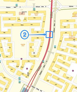
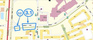
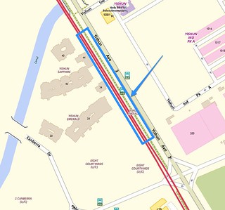
3) There's also more examples of 90-degree tight turns along Block 602. Then at the end of it (see the part marked 3.2) it's a dead-end for the bike path. You actually have to go on the pedestrian path to make the crossing to the PCN on Mandai. I find that part poorly-designed and inconvenient. I end up cycling on the pedestrian path leading to the traffic lights.
Khatib Bongsu PCN - 3


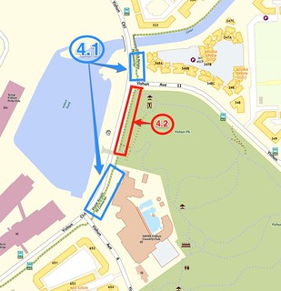
4.1) At the stretch after the canal bridge (from Block 323) to the SAFRA Clubhouse: When the path was first constructed, I remember the asphalt part was designated as the bike path. But one day, the asphalt path became re-designated as a footpath while the concrete path (with iron grills for rain runoff) became a bike path. Pedestrians and cyclists get confused. Plus, the iron grills are not ideal when riding conditions are wet.

4.2) According to the map, it looks like a continuous PCN. But in reality, that stretch is a pedestrian footpath. Not a problem sharing the path, though it is rather narrow.
Khatib Bongsu PCN - 4


5) At Yishun MRT station, the hedges have gown quite tall (near the NTUC part). Pedestrian paths intersect the bike path and the hedges tend to prevent both pedestrians and cyclists from being able to spot each other far away. I try to ring my bell but not all the time. BTW, the same limited visibility issue affects some points along the Khatib-Yishun-Sembawang MRT tracks, where the cycling paths intersect with bus-stops/ overhead bridges pathways. Instead of plantings, the concrete columns are the ones preventing a clear view of oncoming pedestrians/ cyclists.
Feedback on Khatib Bongsu PCN - 5


6) Outside Yishun Emerald Green condo, ideally the bike path and pedestrian paths should be switched. I've seen condo residents coming out the gates and naturally walking on the asphalt path, with is more immediate than the concrete footpath. My point is the bike path should be made further away from the gates, not the nearest.
6Feedback on Khatib Bongsu PCN - 6


7) The stretch along the Canberra Sembawang PCN: the asphalt seems badly eroded. Ride is very bumpy. Cyclists often avoid it and go on the pedestrian path instead.
Feedback on Khatib Bongsu PCN - 7


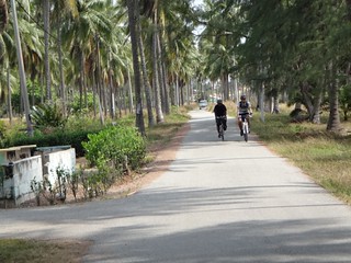
8) On some park connectors (like Simpang Kiri), the bicycle symbol has been painted on the left and footsteps painted on the right. I've noticed cyclists, runners and pedestrians naturally ride/ run/ walk on the left side when heading towards the same direction. And it's usually the left side. If I were to cycle back the opposite direction AND adhered to the designated cycling side, it means I'd be cycling on the right side now, going in the forward direction (or the left side to the opposite cyclist/ runner/ pedestrian). If another cyclist were to head towards me, we're headed towards each other on the same side. It's currently not clear who has right of way -- should I go left or the other move to their left? A game of 'who brakes/ moves first'. In the end, I find that most cyclists/ runners/ pedestrians ignore the marked designated paths and naturally adopt a "keep left" position. In my view, just sticking to a "keep left" principle for everyone would be clearer. Paint a "Kept Left" on the asphalt.
Feedback on the Simpang Kiri Park Connector


Alright. Finally managed to 'dump' all the observations that I think can be resolved in the near term. It's not exhaustive of course. Maybe there are budgetary or infrastructural reasons that prevent more significant improvements to be made. In any case, I hope the feedback would be of use to the authorities (NParks? URA? LTA?)

Would be great if there was a dedicated Singapore Government website on the National Cycling Plan. For now, one can refer to the 2012 Budget website (near the end of the page). Or see this post of Mr Lui Tuck Yew's (Minister for Transport) parliament speech on 7 Mar 2012, where he mentioned the National Cycling Plan and Cycling Paths.

Singapore Budget 2012 - Expenditure Overview

Integrating Cycling with Public Transport | Green Transport | Land Transport Authority

I'm glad to see that cycling was once again part of the Budget in 2013.
Budget 2013: Off-road cycling paths to increase; On-road cycling studied

I've written about how I appreciate our Park Connector Network. If there was one on the National Cycling Plan, I'd love to be part of it.
Our SG Conversation

ASIDE: I can now better appreciate the usefulness of having a National Conversation framework. Previously I've not been that enthusiastic about any of the National Conversation topics. But thinking about the National Cycling Plan, I'd like to listen to the official views, their thinking behind the plans, and also be able to constructively provide feedback and ideas.

(Thanks to Siva for the idea to blog my suggestions, and for reposting at the Cycling In Singapore) blog.

Tuesday, April 09, 2013

Part 1 - Tripping on Two Wheels: Pengarang to Desaru, and Back Again:Cycling Adventure 29 - 30 Mar 2013

Total time on the bicycle: 10 hours, thereabouts.

Total distance covered: about 112km over 2 days (51km each way).

Total energy burned: pretty sure it's 1,800 calories at least (extrapolating from my own 40 km rides in Singapore).

Total energy consumed: Won't be surprised if it's more than what I burned, so I don't really want to know.

2013-03-31-21.47.48-tanjung-pengelih-desaru
[Image credit: Kenneth Pinto, CC-BY-NC)

My first post for 2013 would be a post about my first real ride for the year. Quite apt.

This post is a recap of the 1.5 day ride.

The "Good Friday" some two weeks ago was literally great for me, as 10 of us embarked on a day-and-a-half, Out-of-Singapore cycling adventure. From Tanjung Pengelih to this resort in Desaru, and back.

We were a motley mix comprising of 20 year-olds to mid-40s, on Foldies and mountain bikes.

The day's adventure started at Changi Village. The jetty was packed, given it was a holiday. While we waited for our turn to get a boat and to clear customs, Kevin's super-sized Pugsley earned easy conversations from strangers. He's the original Aunty-Killer. "Got motor or not?" must be the most frequently asked question about his Fatbike.
018_ZendogsDesaru-29_30mar2013
[Image credit: sivasothi, CC-BY-NC-SA]

When my friends first planned for the trip, I thought Pengarang sounded familiar. Then I remembered it was in the news in late 2011 over the Malaysian government's plans to build petrochemical projects there.

On our way to Tanjung Pengelih, we saw Singapore's attempt to create more land. Our bumboat chugged past silent monster rigs, some in the process of turning sea into land. We passed stretches of massive sand banks on both sides, stable enough to support several heavy vehicles on them.

ZenDogs Desaru Adventure (112km, 29-30 March 2013) - 018
[image credit: Kevin Lim, CC-BY-NC-SA]

ZenDogs Desaru Adventure (112km, 29-30 March 2013) - 016
[image credit: Kevin Lim, CC-BY-NC-SA]

2013-03-30 15.02.34
[image credit: Kenneth Pinto, CC-BY-NC]


When we reached Tanjung Pengelih, things felt slower and more idyllic. Probably the absence of human traffic at the jetty. We were the only ones clearing customs.

As we geared up to start our ride, Dinesh provided timely advice on general safety. He also prepared a set of walkie-talkies for the lead rider (him) and last Outrider (Kevin). I was quietly impressed. Talk about being professional.

Being a naturally cautious (i.e. overly pessimistic) person, I kinda surprised myself by feeling rather calm when we set off. I'm chicken-crap when it comes to new places. But this group had plenty of experienced and steady riders. Plus, I trusted my bike and that helped a lot. I'd stopped cycling for about three months, and only put in maybe 5 km worth of riding time a few days before the trip. It was enough to assure me of the ride-worthiness of my foldable bike though. Would have wanted to put in more kilometres for physical fitness (but maybe that turned out to be a blessing -- more of this in Part 2).

We rode through quiet paths with uncut grass waving on either sides; past houses at one stretch, and then hitting open roads with relatively few cars.

ZenDogs Desaru Adventure (112km, 29-30 March 2013) - 032
[image credit: Kevin Lim, CC-BY-NC-SA]

ZenDogs Desaru Adventure (112km, 29-30 March 2013) - 027
[image credit: Kevin Lim, CC-BY-NC-SA]

069_ZendogsDesaru-29_30mar2013
[image credit: sivasothi, CC-BY-NC-SA]

ZenDogs Desaru Adventure (112km, 29-30 March 2013) - 085
[image credit: Kevin Lim, CC-BY-NC-SA]

Along the expressway to Desaru,  a few of us were mystified by this scene we rolled by. What we thought was a trained monkey was actually a child in brown clothing being directed by his father to pick up something from the roadside. What that be?
[image credit: Kevin Lim, CC-BY-NC-SA]


There's a certain zen when one rides under one's own power: hearing the hum and whirs of the bicycle, our own breathing, the wind in our faces.

This was a leisurely ride. The 20-somethings in our group had the benefit of youth. They easily kept up on their bikes. Actually the second (maybe third) oldest guy in our group used to run triathlons.

The Pengarang highways, perhaps being such long stretches, had the inevitable potholes. A few of us had bottles pop out of their bottle cages when they went through deeper potholes.

I had trepidations taking my foldie over a path with sharp chunky gravel. It was one of those "mind-over-matter" moments: tell yourself you might lose balance and you would. I had split microseconds of doubts when traversing the rough patch, but told myself to keep focused and stay balanced. And I did.

The sharp gravel probably got my front tire wall torn (see Part 3). But no puncture.

Riding in Pengarang was vastly different from cycling on Singapore's PCNs. The lack of urban noises created a different experience. In Singapore, there is no escaping the signs of urban constructs -- pedestrian paths, roads, traffic lights, street lamps. But that's just a fact. I suppose if one craved for open spaces, then a place like Pengarang would be superior to the cityscape of Singapore.

As we rode through kampungs (do they refer to their collective homes as kampungs in Pengarang?) the kids seem to be quicker to say Hello, and the adults more generous with their smiles.

Well, we didn't meet that many kids or adults, to be fair. But I've to say the drivers we passed by in Pengarang tended to wait for you to ride past before they made that turn. I sped up to make sure I didn't waste their time, but I didn't feel panicky. It was nice to wave them an acknowledgement, and seeing them wave back in return. Cars went fast on the highways, but most provided a wide berth between their cars and us.

Fact of life, I suppose: having ample space tend to create an air of generosity. It's the place that affect the vibes. Now THAT, I am envious -- of the vast land that Malaysians have.

Speaking of vibes, Siva blogged that he found it depressing in seeing large tracts of land cleared for timber, and basically left bare with no plans for development.

ZenDogs Desaru Adventure (112km, 29-30 March 2013) - 072
[Image credit: Kevin Lim (CC-BY-NC-SA]

Siva observed that traffic conditions will change and will affect some of the village detours. Meaning, the rides may become less idyllic and there will be an increase in traffic.

ZenDogs Desaru Adventure (112km, 29-30 March 2013) - 106
[Image credit: Kevin Lim (CC-BY-NC-SA]

Ah, meals.

The favourable currency exchange rates for Singapore dollar meant we ate like 'royalty' there.

Lunch, on both days, was in the town centre called Pulai Sungei Ringgit ("money town"?).

ZenDogs Desaru Adventure (112km, 29-30 March 2013) - 052
[Image credit: Kevin Lim (CC-BY-NC-SA]

They still have old-style hawker carts plying the town, like this beancurd seller who came by on our return leg. But her product has been modernised. She offered Hong Kong-styled beancurd pudding rather than the traditional type (much to the disappointment of one young rider in our group):
ZenDogs Desaru Adventure (112km, 29-30 March 2013) - 166
[Image credit: Kevin Lim (CC-BY-NC-SA]


The entire trip was largely problem-free. Maybe Kenneth (who opted for his Foldie rather than a MTB for this trip) would disagree. His foldie had a flat on day-one. But I thought the flat was resolved rather easily and in relative comfort. Understandably, he was frustrated with getting a puncture (seemed every ride to Pengarang he would get a flat). Still, the flat was discovered just as we set off after lunch. It would have been worse if the flat happened on an open road.

And then Kenneth discovered his spare inner tube had an inherent flat! I was glad I could help by giving one of my spare (the advantage of having similar sized tires, woo-hoo). Kevin even found a bicycle shop that sold tubes a few metres down the coffeeshop. Good to note for future rides.

Kenneth managed to fix the problem in the shade at a kopi tiam. The iced coffee was pretty good too.

ZenDogs Desaru Adventure (112km, 29-30 March 2013) - 057
[Image credit: Kevin Lim (CC-BY-NC-SA]

Several Firsts for me in this trip:

  • Bringing my own bicycle on a boat
  • Travelling out of Singapore with it
  • Visiting Pengarang and Desaru


My last visit to Malaysia was about 10 years ago. It was quite telling because on Day 2, when I passed a Five Ringgit note to a shopkeeper, he didn't accept the note instantly. He looked at me and said, "Ringgit". I thought I'd brought Indonesia Rupiah by mistake. But no, the note said Ringgit and I pointed that out to him. The guy did a double take, as if he'd never seen the note before. Maybe he hadn't. The note has been out of circulation for years, I was later told.

The pace the group set was comfortable. Properly prepared (e.g. individual strategies to stay hydrated; physical preparation before the trip) this was/ would have been an easy ride.

Distance-wise, each day's ride was about 10km longer than my Yishun-Woodlands Waterfront PCN rides. One big difference was the hills in the last 20 km to the resort. They weren't the Killer Slopes that I thought they would be. I've found the NTU slopes were a lot more challenging. But I suspect my relatively lack of cycling fitness, with the 3-litres of water on me, gave rise to an inflamed tendon near the knee (I'll blog about that in Part 2).

I had looked forward to this cycling trip with the ZenDogs. I wasn't disappointed, even with the sore tendons. Very glad I went. Next time, I shall have to sacrifice the welfare of my dog and get my wife to join me (if you're a dog owner with a namby-pamby dog, you'l know what I'm talking about).

ZenDogs Desaru Adventure (112km, 29-30 March 2013) - 156
[image credit: Kevin Lim, CC-BY-NC-SA]

Kevin's photoset | Kenneth's photoset | Siva's photoset


Part 1 - Tripping on Two Wheels [This post]
Part 2 - Physical Prep & Post-Mortem
Part 3 - Post-ride Bike Upgrades